Trekking Huayhuash Climb Diablo Mudo (5350 m) & Climbing Nevado Vallunaraju (5686 m)
- Home
- Trekking and Mountaineering in Peru
- Trekking Huayhuash Climb Diablo Mudo…
The Cordillera Huayhuash (Huayhuash Range): The Huayhuash Range is the second highest tropical mountain chain in the world, after the Cordillera Blanca (White Range), immediately to the north. Even though it is located 120 kilometers from the Pacific Ocean, the crest forms part of the Continental Divide of South America; the waters of the eastern slope flow to the Marañon River, a principal tributary of the Amazon.
Running from north to south, the main zone that has some twenty summits within about 25 km, with a secondary mountain change of summits of lower elevation toward the west that is about 15 km long. Six of the peaks are higher than 6,000 meters. Among the peaks, Yerupajá (6,617 m) stands out – it is the second highest mountain in Peru (after Huascarán, at 6,768 m.) Also of note is Siula Grande (6,344 m), which achieved fame through the book and subsequent film “Tocando el Vacio“ (Touching the Void) by mountaineer Joe Simpson.
This area also hosts dozens of glacial lakes of incomparable beauty. The closest towns are Chiquián (3,400 m) and Cajatambo (3,375 m)
Vallunaraju Peak: The high peak of North Vallunaraju, 5,686 meters, is close enough to Huaraz to do a summit trek in two days via a moderate climb. Setting out for this peak, it’s possible to see other peaks of the northern part of the Cordillera Blanca, including Oxshapalca (5,881 m) and Ranrapalca (6,262 m). Vallunaraju faces the city of Huaraz, and from the summit you can see Huaraz and the Callejón de Huaylas (central area of the valley between the Cordilleras Blanca and Negra.) Between these two summits there are 5 routes; we will follow the route of the first ascent 1949. It is also good place for ski mountaineering.
Highlights of the Cordillera Blanca. The highest tropical mountain range in the world, the Cordillera Blanca is part of the spectacular Andes that form the spine of South America. A mecca for hikers and outdoor enthusiasts, the region boasts over 50 peaks that exceed 15,000 feet, 700 glaciers and 300 lakes.
- 20 Days/19 Nights
- May to November
- Moderate


Travel Program
Day 1: Flight to Lima - Lodging in the hotel
Arrival in Lima – the large city in South America; population approximately 11 million. Rest or explore the city on your own.
Overnight
Hotel
Meals
B/L/-
Day 2: Travel by bus to Huaraz (3100m). The trip is 400km and takes 8 hours
This ride follows the Pan American highway north across the impressive Pacific coastal desert. Continuing toward higher terrain, we pass through the Cordillera Negra (Black Range) at Conococha Pass (4020 m) into the Santa Valley and Huaraz (3100m.) Once across the pass, you’ll see a charming view of the mountains of the Cordillera Blanca, without a doubt some of the most impressive scenery in the world. You can also fly via LCPERU – flight duration 50 minutes.
Overnight
Hotel
Driving
8 hours aprox.
Meals
B/L/-
Day 3: Huaraz - Trekking to Laguna 69 (4450 m) - Huaraz
Laguna 69 has been called the most famous and well known lake in the Cordillera Blanca. Our trail winds through picturesque montane forests and a somewhat marshy area, always alongside a steep and daunting ridge. Behind us, the fortress-like peak of the ice giant Huascarán looms. Winding trails lead us past several wild foaming waterfalls to the lake. Laguna 69 is flanked by glacial moraines. Immediately above the deep blue surface of the lake, we see the steep ice walls of Chacraraju, one of the most beautiful, but also most difficult of the 6000 peaks in the Cordillera Blanca. After rest and pictures, we return to Huaraz.
Overnight
Hotel
Driving
6 hours aprox.
Hiking
6 hours aprox
Meals
B/L/-
Day 4: Huaraz - Transfer Cordillera Huayhuash - Camp Matacancha (4150 m)
Transfer in van via the Santa Valley across the Pachacoto Bridge, then continue on the mountain road in Puja Raimondi National Park (4,780 m) to Huarapasca Pass. Along this road we see giant plants in the form of a candle which flourish only in the south of the Cordillera Blanca. At the top of the pass, you’ll see the Pasto Ruri glacier. Continuing over 2 more passes to the village of Matacancha (4,150 m) in the Huayhuash region, the starting point of the trekking circuit. Meet with the team of guides, the mule drivers (and their burros) and first
Overnight
Camping
Driving
4 hours aprox.
Hiking
Only camping
Meals
B/L/-
Day 5: Matacancha - Trekking to Cacanampunta (4700 m) - Laguna Mitococha (4300m)
First day of trekking: Climb the steep slope of Matacancha to Cacanampunta Pass (4,700 m), which forms the continental divide between the Pacific and Atlantic Oceans, and the spectacular open views of the wild mountains of Huayhuash, in particular the peaks of Rondoy and Jirishanca. Descent over wide fields and a beautiful camp at Laguna Mitococha (4300 m).
Overnight
Camping
Hiking
3 hours aprox
Meals
B/L/D
Day 6: Mitucocha - Trekking to Punta Carhuac Pass (4640 m) - Laguna Carhuacocha (4200 m)
An inviting climb to Punta Carhuac Pass (4,650 m) and descent over smooth rolling grasslands to Carhuacocha Lake (4,200 m), one of the best campsites on the route. If there is no wind, we’ll see the peaks of rock and ice (Jirishancas and Yerupajá Grande y Chico) reflected on the surface of the calm waters. At the lake live indigenous farmers – with their permission we may get to catch fresh trout for dinner!
Overnight
Camping
Hiking
4 hours aprox
Meals
B/L/D
Day 7: Carhuacocha - Trekking to Siula Pass (4950 m) / Laguna Quesillococha – Huayhuash (4450 m)
This part of the route is strenuous and has no obvious road. It passes through remote peaks and glaciers of Huayhuash, with the most magnificent panoramic view of the excursion. We pass Lake Carhuacocha and beyond that is the ice fall and retreating glacier of Sarapo Peak (6127m). We cross Siula Pass (4950 m) with overwhelming panoramic views. The descent into camp at Quesillococha Camp (4450 m), close to the small village of Carnicero, seems effortless after the climb.
Alternative: If you prefer an easier day, there is a route that is a little longer but less demanding and less steep: flat along the east edge of Lake Carhuacocha, climb through the Quebrada Acoshpado to the summit of Carnicero Point (4580 m) and the smooth descent to the two lakes of Atocshaiko to Carnicero Camp or Camp Huayhuash at Quesillococha Lake (4450 m).
Overnight
Camping
Hiking
7 hours aprox
Meals
B/L/D
Day 8: Huayhuash - Trekking to the village of Portachuelo de Huayhuash – Laguna Viconga / Hot Springs (4400 m)
A wide commercial route extends to the south to the small village Portachuelo de Huayhuash, then to the headwaters of the Huayhuash River – the very green Suirococha Lakes (,500 m.) The climb to the south extends past Portachuelo de Huayhuash (4795 m) again dominated by impressive mountain panoramas, this time the ice covered peaks of the southern Huayhuash Range. Descend to the largest lake, and the southernmost point of the trek – Lake Viconga (4,400 m), one of the many water reservoirs for Lima. Viconga Hot Springs Camp (4400 m).
Overnight
Camping
Hiking
4 hours aprox
Meals
B/L/D
Day 9: Laguna Viconga - Trekking to Punta Cuyoc Pass (5020 m) - Huanacpatay (4350 m)
Today is the highest pass of the Huayhuash Trek over Punto Cuyoc (5020 m). From the lake of Puscanturpa Gorge, we scramble over rocks and sand to the pass. The spectacular view is of the Raura Range to the east. The Puscanturpa Peaks loom very close and “giants” of Huayhuash, Sarapo, Siula and Yerupajá. We drop sharply to Huanacpatay Gorge and camp in fields close to the houses of Huanacpatay (4350 m).
Overnight
Camping
Hiking
5 hours aprox
Meals
B/L/D
Day 10: Huanacpatay - Trekking to Village of Huayllapa (3600 m) - Huatiac (4290 m)
We hike along the river to the Calinca Valley (Rio Huayllapa) and continue to the village of Huayllapa (3,600 m). In the relatively low elevation, the trail takes us through dense vegetation with many colors of flowers – especially the shrubs called huishllac, named for their yellow color and open purple flowers, one of the sacred flowers of the Incas. We then have steep 3-hour climb to the north to camp in Huatiac (4290 m).
Overnight
Camping
Hiking
5 hours aprox
Meals
B/L/D
Day 11: Huatiac - Trekking to Punta Tapush (4800 m) - Cashpapampa (4500 m)
At times the climb is steep and strenuous, under the steep glaciated cliffs of the high massif of Raju Collota to Punta Tapush Pass. Once again, magnificent views, including Nevado Diablo Mudo (Silent Devil) (5,350 m), tomorrow’s destination for the ambitious and physically strong climbers among us. Short descent from the pass north to Susococha Lake (4,600 m) and a little farther to Cashgapampa Camp (4500 m).
Overnight
Camping
Hiking
4 hours aprox
Meals
B/L/D
Day 12: Cashgapampa - Trekking to Llaucha Pass (4750 m) - Laguna Jahuacocha (4066 m), Optional: Climb Diablo Mudo (5350 m)
Those climbing Diablo Mudo (5223 m) begin very early and will have a long day. From the north side on the last steepest slopes, some with “penitentes“, we’ll use crampons, ice axe and harness. The feeling of success at reaching 5000 meters, and awesome views in the true sense of the word, Diablo Mudo is a well-deserved reward for the effort. The huge wild mountains of Huayhuash are laid out in front of you. Descent to the camp still follows the long route to Jahuacocha Lake.
Option: Trekking without climbing Diablo Mudo. Short descent from Cashgapampa, turning into Angocancha Gorge (4350 m) and ascent to Yaucha Pass (4750 m), where we again stop and enjoy the impressive view. Steep descent toward the northeast in Huacrish Gorge (4,066 m), leading to Jahuacocha Lake (4066 m). Camp on the edge of the lake, with a view dominated by Rondoy, Jirishanca and Yerupajá.
Overnight
Camping
Hiking
5 hours aprox
Climbing
12 hours aprox
Meals
B/L/D
Day 13: Rest Day at Jahuacocha Lake. Optional: Trekking to the Berlin Mountain overlook (5,094 m) or to Sambuya/Rondoy Pass (4,750 m) or to Solteracocha Lake
Rest day or 3 possible activities: Unhurried hike to Solteracocha Lake, or the ultimate mountaineering tour with an ascent of the very easy (non-technical) Cerro Berlin (5094 m) or to Sambuya/Rondoy Pass (4,750 m).
Overnight
Camping
Hiking
5 hours aprox
Meals
B/L/D
Day 14: Jahuacocha - Trekking to Jahuapunta Pass (4650 m) - Village of Pocpa (3600 m); Transfer to Huaraz
Last day of this trek. Climb the last pass – Jahua Punta – and a long descent to the camp in the village of Pocpa. In this village we finish our great adventure filled with so many experiences. Here we leave our team of mule drivers and burros. Our private transport is waiting to return to the capital of Andes mountaineering, Huaraz.
Overnight
Hotel
Driving
4 hours aprox.
Hiking
5 hours aprox
Meals
B/L/-
Day 15: Rest Day in Huaraz – Optional: Rock climbing at the walls of Chancos.
Relaxing day in Huaraz. Optional: A classic location for many who like to practice rock climbing. This area is 40 minutes north of Huaraz. It was developed thanks to the guides of Don Bosco in the Andes in 1997. It has 8 developed routes of different difficulties. This is a good place to spend a quiet day in nature and at the end visit the hot springs to relax aching muscles.
Overnight
Hotel
Driving
1 hour aprox.
Hiking
Hots spring
Meals
B/-/-
Day 16: Huaraz - Transfer Quebrada de Llaca - Moraine Camp (4900 m)
Leave from Huaraz in our private bus to the Llaca Valley (3850 m), from here we begin our 2-hour ascent on foot to Moraine Camp (4,900 m.) This climb is relatively long and steep, so we have to proceed quite slowly so we save our energy for the summit day tomorrow.
Overnight
Camping
Driving
2 hours aprox.
Hiking
3 hours aprox
Meals
B/L/D
Day 17: Moraine Camp - Summit of Nevado Vallunaraju (5686 m) - Moraine Camp - Transfer to Huaraz
Leave Moraine Camp approximately 2-3 a.m. in order to reach the summit by about 8 a.m. This section of the moraine, at the upper part of the glacier, takes us 5-6 hours. After arriving at the summit, we will return to our starting point in the Llaca Valley where the bus waits to take us back to Huaraz.
Overnight
Hotel
Hiking
3 hours aprox
Climbing
7 hours approx
Meals
B/L/-
Day 18: Transfer to the Anta Airport and 50 minute flight to Lima - transfer to the hotel.
Options: Flight or bus. Flights are via LC-Peru and last 50 minutes.
Overnight
Hotel
Driving
8 hours aprox.
Meals
B/-/-
Day 19: Stay in Lima, transfer to the airport.
Free day, depending on your departure schedule. Return to Europe or your country of origin.
Overnight
Hotel
Driving
1 hour aprox.
Meals
B/-/-
Day 20: Arrival to Europe or your country of origin.
Arrival in USA or Austria, Switzerland,Germany, etc. Overnight Hotel (-/-/-)
Included meals: B=breakfast; L=lunch; D=dinner
What's Included
Services included in the prices:
- Acclimatization Tour
- Peruvian qualified and experienced local guide/s
- Entrance fees to the Huascaran National Park
- Cooks and helpers
- All meals during the tour
- Donkey driver and donkeys
- Camping tents
- Porter for Nevado Vallunaraju
- Kitchen equipment
- Transportation as tour schedule / Huaraz
- Pick up at the airport in Lima to the Hotel
- Transfer from the Hotel to the airport and bus station
- Transport public bus or Domestic flight Airline LC-Peru
- Hotel Kamana 2 nights in Lima or other hotel
- Hotel Casa Blanca 3 nights in Huaraz or other hotel
Not included:
- International flights to Lima / Peru round trip
- Transfer from the airport for bookings of individual flights with different times of arrival / departure
- Exit tax at the airport in Lima
- Travel accident and health insurance
- Luggage insurance and trip cancellation
- Meals in restaurants in Lima and Huaraz
- Personal expenses
- Personal equipment (such as boots, ice ax, crampons, harness, sleeping bag, mat, Goretex, etc.)
- Tips
What to Bring
What to Bring or take fo Day Hiking and Technical Equipment for Climbing Expedition
This equipment list is compiled to provide you with adequate help when choosing your equipment for a climb. Most items are required. Please consider each of them and make sure you understand the function and exclusive use for mountaineering, before substituting or removing items from this list. Please note that this list has been carefully annotated by the organizer. Remember that mountaineering, mountaineering or mountaineering is an extreme, risky sport, therefore everything related to it is of great attention.
These items should be on your hiking checklist:
Hiking backpack for hiking 30 to 40 liters
Light gloves for hiking or (Optional Mittens waterproof)
Medium weight socks
Sleeping bag (-10º to 15ºC)
Small daypack for one day hiking 20 liters
Weather-appropriate clothing (think moisture-wicking and layers)
Hiking boots or shoes
Medium weight parka with fibber fill or down
Rain poncho (or rain gear)
Long-sleeved shirts
Fleece or Wool sweater and/or trousers
Lightweight pants
Cotton short-sleeved shirts or t-shirts
Water bottle for hiking or trekking
Strong waterproof duffel bag
Flashlight with spare batteries and bulb
Towel for personal hygiene each participantFirst-aid kit
Regular and long underwear
Knife or multi-tool
Light cap and wool hat
Sunglasses with UV certification, Sun block, lips
The rest of the list Essentials as appropriate for your hike
Grooming and personal hygiene kit
One Hiking Buff per person
Technical Equipment for High Altitude Expedition Mountains
3 Locking carabiners, we recommended per person
We recommend 2 ice screws for each client
1 Daisy Chain (Life Line) per each person
2 Ice axes (per person) technical, we recommended GRIVEL company
1 ATC descender (Rappel), this is very necessary for technical mountains
2 Cords for prusik, very important (Size Cord 6 mm x 10 m. long)
Gloves(Good gloves) for expeditions over 6000meters
Harness, we recommended GRIVEL company
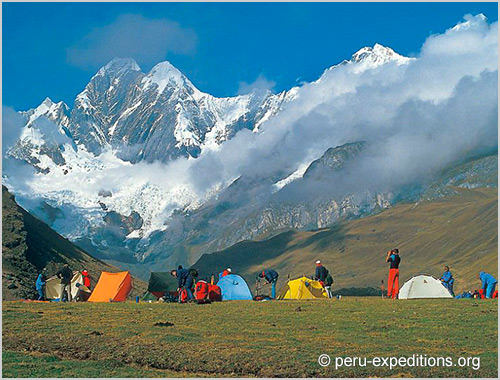
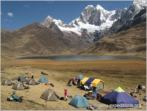
Sleeping pad / Mattress, we recommend with air or inflatable mattress
Crampons, we recommended GRIVEL company
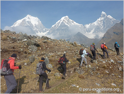
Walking sticks (optional), a pair per person, we recommended GRIVEL company
Down Jacket for expedition
Very important to have personal clothing such as pants and jacket with GOROTEX certification
First aid kit, for high mountains, because we as guides cannot medicate clients
Backpack Capacity 60 liters, it is better to have a bigger backpack to go comfortably to the high camps, because here you have to carry all your personal things
Gaiters or Leggings, now modern boots already have built-in (Incorporated), but better to have an extra pair
Dressing appropriately for the mountains can make the difference between a pleasant trip and a really uncomfortable one. Clothing must provide the right degree of temperature, perspiration and be well ventilated. Preferably cotton clothing should be avoided, as in humid conditions they absorb body heat.
In general, the weather conditions in in the Andes of South America can vary from day to day and even throughout the day. Therefore, clothing must be versatile.
Please do not hesitate to contact us with any questions you may have regarding the necessary equipment.
Prices & Dates
FROM/TO
PRICE (USD)
TRAVEL STATUS
–
FROM/TO
PRICE (USD)
TRAVEL STATUS
–
FROM/TO
PRICE (USD)
TRAVEL STATUS
–
FROM/TO
PRICE (USD)
TRAVEL STATUS
–
» Additional dates available upon request
» Rates may vary from July 26th to 31th for the national holidays
Prices (per person):
1 PAX | 2 PAX | 4 PAX | 6 PAX | 8 PAX | 10 PAX | 12 PAX | 14 PAX |
---|---|---|---|---|---|---|---|
— USD | — USD | — USD | — USD | — USD | — USD | — USD | — USD |
Deposit for reservations: — USD (– EUR) ✓ Full payment 40 days before. No refund if you cancel less than 30 days!
Places: *Available
Trip-code: Number ►PER-
Duration: 20 days
Participants: Minimal: 4 Maximal: 12
Members: We don’t have an open group to join – We can open a new group – Contact us!
Country / Location: Peru
Mountain Guide: Juventino Albino Caldua
Other dates / additional info: Contact us!
3% early bird discount when booking 6 months prior to departure 2023
Legend Booking-information:
EZZ Single room supplement
🟢 On this trip, places are still available.
🟡 On this trip, only a few places left.
🔴 This trip is sold out / closed.

Juventino Albino Caldua
Expert guide certified by IVBV - UIAGM - IFMGA
Co-Founder, Peru Expeditions
- WhatsApp: +51 943 081 066
- E-Mail: [email protected]
Videos
- Recommended Tours